top_triangle28x18

East Coast Greenway in DE

Delaware proudly hosts a portion of the East Coast Greenway – a 3,000 mile non-motorized walking and biking trail in development from Maine to Florida, connecting our nation’s most populated corridor. Efforts are under way to completely finish the Delaware section of the ECG.

Length:       38 mi (when complete)
Surface:      Paved & Road Segments
Difficulty:   Easy-Moderate

View Trail Plan

The East Coast Greenway in Delaware

The East Coast Greenway, when complete, will offer a safe place for bicyclists, walkers, runners and more – of all ages and abilities – to commute, exercise, and visit new destinations from Maine to Florida.

As Delaware continues to expand its trail network, we may be the first state to complete the route of the East Coast Greenway within its borders. Currently, over 1/3 of the Greenway is complete nationally, but much more is complete in Delaware: nearly 3/4 of the Greenway is on off-road trails for a total of 27 miles of Greenway in the First State. Please note that the map shows the entire East Coast Greenway route through Delaware, which includes both trail and on-road segments between the trails. For more information on what to expect when navigating the route, go to greenway.org/route-map.

ECG in Delaware Segments: Completed

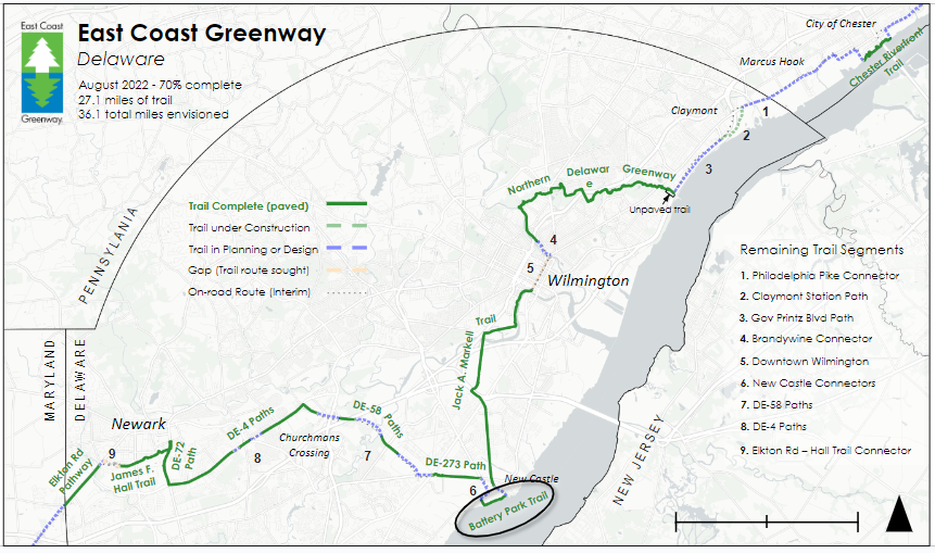
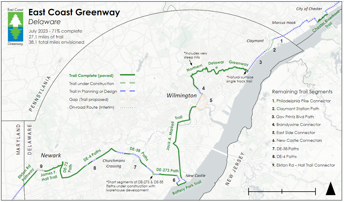
This section, an especially important component for local and long distance commuters, was completed in Fall 2023, and is 1.2 miles in length. 

The Northern Delaware Greenway links Bellevue State Park and Brandywine Park and the City of Wilmington through 10.4 miles of asphalt trails that travel some of the most beautiful landscapes in Delaware. More information, including maps, on the Northern Delaware Greenway Trail page.

The Jack A. Markell Trail completes a long-awaited connection between the city of Wilmington (including the Amtrak Station) and New Castle Battery Park.  That connection  consists of an off-road elevated boardwalk and paved pathways, the Wilmington Riverwalk, and one on-road section through Historic New Castle, totaling 7.9 miles. More information, including maps on the Markell Trail page. 

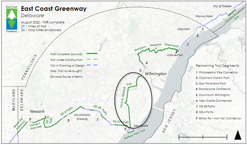
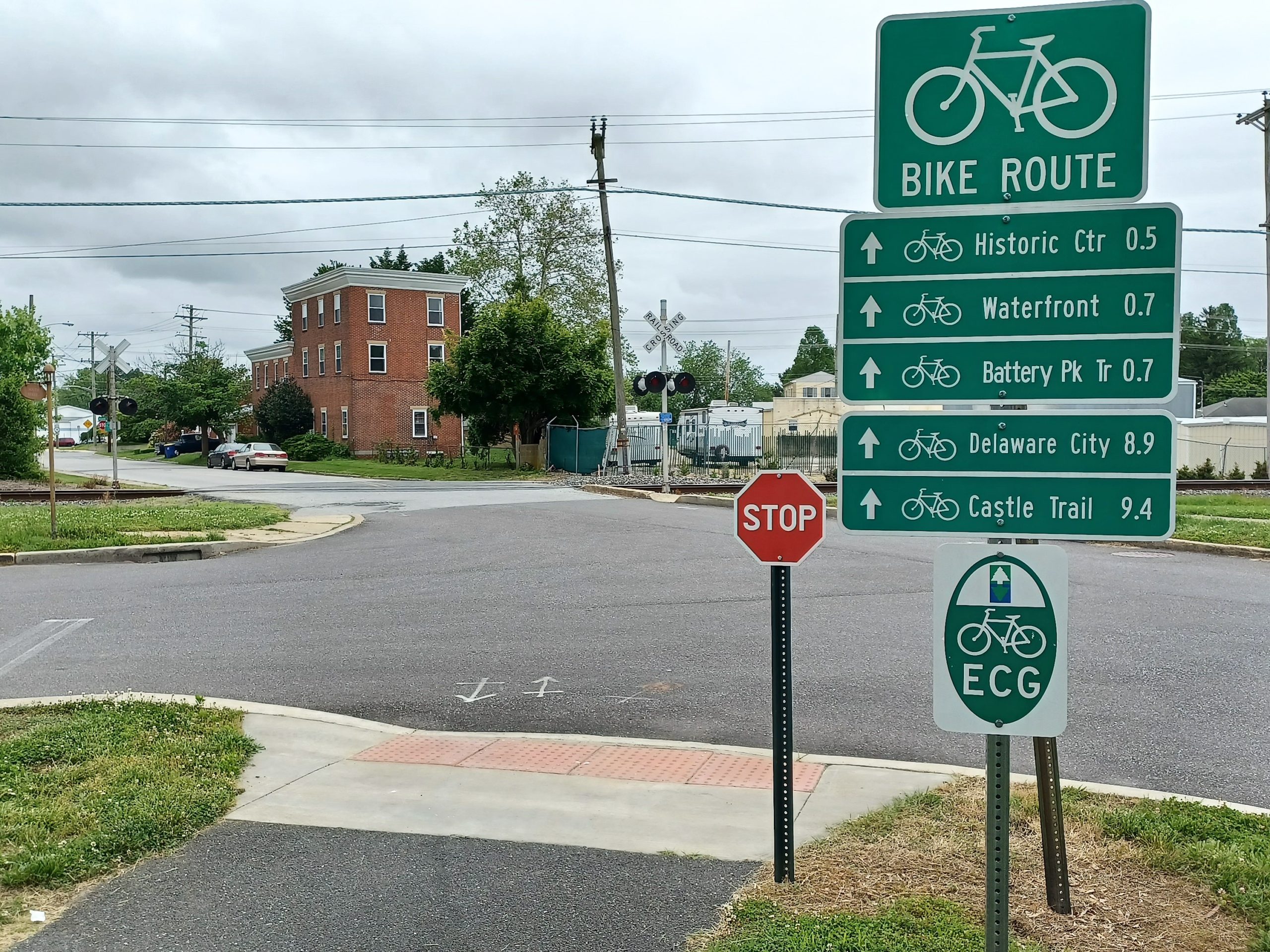
The Battery Park Trail is a 3.7 mile paved walking, hiking and biking trail in Historic New Castle. It runs  along the Delaware River, providing amazing views of waterfowl, ships and the Delaware Memorial Bridge. More information, including maps, on the Battery Park Trail page.

  • The 1.8 mile James F. Hall Trail, a segment of the Newark Bikeways‘ Central Loop, and the southwest section, is great for bicycling, in-line skating, and walking on an urban path that never crosses a road. It runs along the north side of the Amtrak Railroad line and passes through three Newark city parks. For more information, visit the James F. Hall Trail page.

ECG in Delaware Segments: To Be Completed

Photos: Daniel Paschall

Use the map in the photo gallery above (top left) to view location of each segment remaining. Details on each below.

  • Phila. Pike – US Route13 sidepath (0.3 miles) under construction the summer of 2023.
  • Separated bike lanes  (0.5 miles) in planning phase.

    Stay tuned for updates!

US Route 13 – Governor Printz Blvd paved sidepath (1.9 miles) in planning phase.

Read the Governor Printz Boulevard Corridor Study.

Stay tuned for updates!

  • Northern Delaware Greenway – Brandywine Zoo to N Market St. paved trail (0.6 miles) in planning phase.
  • N Market St – Brandywine Creek Bridge protected bike lane (0.1 miles)

Stay tuned for updates!

Protected bike lane (0.9 miles). More details on our Wilmington Loop project page.

Stay tuned for updates!

  • Markell Trail – Industrial Track Trail – Phase 4 paved trail (0.4 miles)
  • New Castle – Clark St paved trail (0.1 miles)
  • New Castle – West 7th St paved trail (0.3 miles)
  • New Castle – Washington St paved trail (0.5 miles)
  • Rt 273 Frenchtown Rd gap (north side) sidepath (0.4 miles)

    Stay tuned for updates!
  • Rt 58 – gap 1 (north side) sidepath (0.9 miles)
  • Rt 58 – gap 2 (north side) sidepath (0.9 miles)
  • Rt 58 – gap 1 (south side) sidewalk/path  (0.6 miles)

    Stay tuned for updates!
  • Rt 4 – gap 1 (south side sidewalk) 0.3 miles
  • Rt 4 – gap 2 (Rt 273 ramp crossing – south to north sidewalks) 0.1 miles
  • Rt 4 – gap 3 (north side residential access road) 0.2 miles


Stay tuned for updates!

  • James F. Hall Trail Connector – Bradford Dr paved trail (0.2 miles)
  • Chrysler Ave paved trail (.04 miles)


Stay tuned for updates!

The remaining ECG Delaware segments are in various stages of the trail building process. Example of that process below.

Trail Building Process Example

Progress

Trail Idea Accepted

Fundraising for Planning Study

Planning Study Complete

Project Fundraising

Project Design Complete

Construction Complete

News on Other Projects

This website uses cookies to ensure you get the best experience on our website.